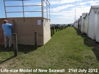
Planning Application: 14/00298/BC3MSea Wall at Thorpe Esplanade and Shoebury Common RoadComments on Planning Application:1. Recent flooding events and current thinking on Coastal ManagementRecent flooding events elsewhere in the country are making the government and experts in flood protection very aware of the need of providing effective, long-term flood protection. The emphasis is moving away from building seawalls but towards utilizing natural features. Such has been the scale of recent dramatic events, with storm surges of 2 metres, as recently experienced in Norfolk, it is unlikely the seawall/embankment planned for Shoebury Common would provide sufficient protection for the period of time intended. Furthermore, it may actually increase the risk of flooding elsewhere. Effective coastal protection is now focussed on building off-shore barriers, rock groynes and beach recharge. A scheme is at present being undertaken at Felixstowe which, like Southend, is an SSSI area. The scheme utilizes rock groynes to dissipate wave energy and reduce shingle erosion, incorporating within the scheme, beach recharge. The same designer, Mott MacDonald, has recently been engaged to develop a system of sea defence for the western area of the Southend frontage. Similarly, at Medmerry in Sussex, flood protection has been provided by a system of managed retreat or managed realignment, whereby the sea has been allowed to flood areas inland, formerly protected, giving back to the sea some land nearest the coast. New sea walls have been built further inland. The Environment Agency describes this scheme as one of the best sea defences on the south coast. At Sea Palling in Norfolk a system of off-shore rock barriers introduced in 1990 prevent storm waves reaching the shore. Lord Deben, Chair of the Committee for Climate Change, stresses the intensity and frequency of extreme weather conditions will increase and the need for a rethink on methods of sea defence. Ed Davey, MP, Energy and Climate Change Secretary, emphasises that flood protection is complicated, there is more than one way to mitigate it and is a top priority for scientists and experts working together. The seawall/embankment scheme planned for Shoebury Common is already outdated and a plan should be adopted utilizing the natural features of the area, working with Nature and not against her. 2. The FloodplainThe area behind the beach huts is an important floodplain. The ground level falls away to the road creating a natural basin. The soil is sandy providing good drainage. Together, these features act as a safety valve to hold and absorb much of any floodwater. This was demonstrated in the 1953 floods when floodwater was largely contained in the basin of the floodplain. Because of this floodplain, property in the area was saved from flooding. 2.1 Effective Floodplain ManagementIn accordance with Environment Agency policy, it is important that, “effective floodplain management is in place”. The existing soil on Shoebury Common is River Terrace Deposits, largely sandy, permeable enabling floodwater to soak through (Southend on Sea Borough Council SFRA Level 1, 2.4.4 and Table 9-2, September 2010). The soil proposing to be deposited on top to form the new embankment is of “stiff London Clay and mixed sands and gravels”, (Southend on Sea Borough Council, “Shoebury Flood Defence FAQ page 3 – July 2012). London Clay is impermeable and water will not soak through easily. London Clay is a material used in the construction of dams. This will have the effect of destroying the natural drainage benefits of the floodplain as it is today. A very large volume of water can be held in the Shoebury Common floodplain. To fill the basin in with an embankment will destroy this natural feature and could well increase the risk of flooding further upriver. Holding seawater back and preventing it from spilling over on to the Common will simply move the problem further along the path of tide, towards Southend. 2.2 Pluvial (Rainwater) FloodingExcessive rainfall in August 2013 collected in Shoebury Common Road. It was able to spread across the cycleway on to Shoebury Common where it was absorbed by the sandy soil there. The rainwater filtered down through the sandy soil, eventually to the clay layer of Tidal Flat Deposits several feet below. From there it gradually drained underground into the Thames. The following day this could be seen taking place on the beach, water was even trickling through narrow joints between the blocks of the seawall. The embankment planned would hold this pluvial floodwater back and cause more flooding to the road, which could well back up to the houses at road level near the Shore House Public House. 3. SecurityThe plan will have a potentially negative impact on security. The area between the backs of the huts that stand on the Common and the new seawall will undoubtedly become a high-risk area, a “muggers’ paradise”. This area will be largely obscured; there will be plenty of hiding places. At present, Shoebury Common Promenade has a fairly open aspect from all sides. It is quite safe for young families and people to come on their own, even in the late evening. A simple pleasure that can be rarely enjoyed these days! This open aspect of the area gives security. There are no hidden corners, activities can be easily seen. Should someone feel their personal safety is threatened, it is quite easy to slip between the huts, on to the Common where you can readily be seen from the road and find help. The new seawall will make this impossible, activities on the Promenade will not be visible from the road and this will undoubtedly increase the potential for bad behaviour, vandalism and assault. Similarly, it would not be long before the wall was adorned with graffiti, but this would be the least of the anti-social behaviour from which the area will suffer. Safety and security are valuable aspects of Shoebury Common, vital for each individual as well as for that of the whole neighbourhood. If the new seawall is positioned behind the huts as is proposed, the relative security of this pleasant environment will be lost forever. The plan does not show the provision of lighting or CCTV cameras, although these have been suggested by the Council. However, it is doubtful these measures would have any beneficial effect to reduce anti-social behaviour. Lighting would not help; it would merely assist the perpetrators of such crimes by illuminating the targets of their activity, no need to bring their own torches. It would not make vandals and muggers visible from the road nor from the houses behind. Motion sensor lights would be triggered by every wandering fox, rabbit or rodent and so soon ignored. Similarly CCTV cameras would only act as a small degree of deterrent. They would need to be continuously manned to alert police and security. The cost of employing someone to watch the monitors would be expensive and instant response would still be out of the question. Perpetrators of such crimes are familiar with the ways of avoiding detection from CCTV footage, wearing hooded clothing for instance. The mere presence of such security measures would greatly reduce the attractiveness of this area. For many years, beach hut owners have been refused planning permission to include roller shutters in the design of their beach huts. The Council Planning Department has said that such measures would give the impression that the area was of a high-security risk. How much more of a bad impression would security lighting and CCTV cameras give! We are quite sure people would choose to stay away if they thought their relaxing on the beach was being observed and recorded, an intrusion into privacy. 4. Change in Character and Nature of the AreaShoebury Common was given at the beginning of the 20th Century to Shoeburyness Urban District Council with restrictive covenants that were designed to ensure it remained: "as an open space for the recreation and benefit of the inhabitants of South Shoebury and others". This responsibility was passed on to Southend Borough Council when Shoeburyness was absorbed into Southend on Sea in the 1930s. The way of life here has changed little since those early days. Shoebury Common is a very special and unique place to us and all who visit it. It is largely unspoilt, has been enjoyed by people over the years and has a charm and character of its own. There is an easy, relaxed, secure atmosphere. Visitors still flock in their thousands, as spells of warm weather last summer proved when it was hard to find a parking space in the car park. Some travel great distances, more are coming from abroad. Generations have come to enjoy the Common and the Beach. Children play where their forefathers have played. Whether it is swimming, mudlarks, impromptu games of cricket on the Common, rounders or kite-flying, it is an important recreation area, vital for personal well-being. A happy, social atmosphere pervades, all are welcome to enjoy themselves and relax from the pressures of modern living. It is good that the town can present to visitors such a pleasant and popular place. It is very sad to see how the proposed changes with its system of walls and floodgates will spoil the place. A system of walls topped with railings with as many as nine ugly floodgates with security lighting and even CCTV cameras will dramatically and irrecoverably alter the whole pleasing appearance to give the impression more of a prison camp than a seaside resort. Similarly, as some preliminary drawings have shown, with the introduction of wooden posts marking out car parking lanes, it will no longer be an “open space”. Youngsters have enjoyed playing games of cricket and football in the car park when there are few cars about. This will no longer be possible. It will cease to be the: "open space for the recreation and benefit of the inhabitants of South Shoebury and others". 5. Disabled accessThe plan shows the provision of a floodgate through which the disabled can drive their cars to access their beach huts. The distance between the planned seawall and the back of the huts, although not detailed on the plans, appears to be similar to the width of the promenade, given as 6 metres. The width occupied by each beach hut, including sideway, is very narrow, less than 3 metres. Disabled owners in adjoining beach huts will not be able to park their cars sideways to their huts, there will be insufficient room. It will be necessary to park at an angle or even directly facing. This will leave little, or no, room behind for other vehicles to pass, effectively blocking the access for other users. The floodgate providing access is shown in the plan as for the use of emergency vehicles also. It is assumed the Council does not envisage emergency vehicles using this area behind the huts but driving along the promenade. Presumably the flower beds that would prevent access for vehicles to the promenade itself will be removed . 6. Depth of PilingThe depth of the steel sheet piled core driven into the ground behind the beach huts will be in the region of some 5 metres. The vibration will no doubt have some effect on the beach huts themselves and could well cause damage. The Council must accept responsibility for any damage caused and offer compensation. 7. Water tapsThe plan does not show where water taps will be positioned. In view of those of limited mobility, these should be positioned on the same level as the beach huts. 8. Loss of PrivacyOccupants of the houses along Lodwick will suffer a loss of privacy. Their gardens could be viewed by those walking along the top of the embankment. 9. Potential Damage to the Local Wildlife SiteBoth Shoebury Common South (LoWS) ref:SOG1 and Shoebury Common North (LoWS) ref: SOG2 are designated Local Wildlife Sites and as such are afforded protection as areas of land with significant wildlife value. As such they can be classified as “sensitive” sites and so an Environmental Impact Assessment would appear to be required. There is no Environmental Impact Assessment or Environmental Statement included with the planning application documents. Amongst the nationally and regionally rare species found here is Bulbous Meadow-grass, a nationally rare plant, found on coastal grasslands. It has survived here where there is a regularly mown, lightly-used car park. The plan indicates that the existing topsoil is to be stripped, re-spread and seeded on completion. Undoubtedly, there must be a risk that the disturbance will have a harmful effect on the rare species of the Wildlife Site. Protection of such sites is a “material consideration” in the determining of planning applications and this should surely ensure a presumption against development on them. 10. Increase risk of flood damage to Beach Huts on the CommonWith a seawall behind the beach huts, there will be an increased risk of damage to the huts at times of storm surge. At present any excess floodwater could swiftly pass between the huts to drain away on the floodplain of the Common. With a new seawall in place, this floodwater would be trapped and have the potential to cause much damage to the huts. Whilst the huts cannot be classed as living accommodation, they are people’s property. The Council states there are 143 huts on the Common, facing south. With the average value of each hut being at about £15,000, the combined total value of the huts would be a figure in excess of £2,000,000. The new seawall/embankment scheme would have considerable impact and increase the risk of flooding to these huts. 11. Floodwater trapped between old and new seawallsThe documentation accompanying the planning application accepts there will be an issue concerning drainage between the old and new seawalls. Before comments can be made on the plan, full details of this need to be viewed and evaluated. 12. Loss of Parking SpacesThe Council accepts there will be a reduction in the number of car parking spaces and proposes Shoebury Common North Car Park is brought back into general use. A large number of the visitors are either elderly or are families with young children. In view of this, three new pedestrian crossings would be needed: one at the extreme west of the Shoebury Common North Car Park, where it adjoins the garden of the house in Lodwick, one opposite Uncle Tom’s Cabin and the third at the junction of Shoebury Common Road with Waterford Road. 13. ConclusionThe plan proposed is potentially damaging to the natural features of the area and could well increase the risk of flooding to property by introducing a dam that will hold back excess inland water. Additionally, by removing the beneficial effects of the floodplain and the volume of floodwater that can be stored there, the risk of flooding could increase in areas further upriver, towards Southend. The plan is short-sighted, costly and unlikely to provide the level of protection for the period intended. It is outdated in view of present thinking. Working with nature in schemes of flood defence is being advocated by experts in the field including: Roger Falconer, Professor of Water Management, Cardiff University Jean Venables, Association of Drainage Authorities Ellie Macdonald, National Trust, which has a long history in managing the coastline. A better scheme would be to utilize natural features, introduce rock groynes, a beach recharge and improve the existing seawall. The higher ground at the back of the Shoebury Common North should be used for the siting of any new seawall needed, thereby giving protection directly adjacent to living accommodation at risk. This seawall could then continue to link up with the existing sea defence in the Garrison area already deemed to be of sufficient height. This would involve only one floodgate across the road instead of the total of nine shown in the proposed plan, thereby providing a saving in cost and maintenance. Ideally, if the adjoining area, both Old and New Gunners’ Parks, were allowed to revert back to marshland and flood at times of extreme weather events, a North Sea Surge for instance, the additional volume of water that could be stored there would considerably reduce the risk of flooding elsewhere, even as far as Southend. If the Shoebury Common and Gunner’s Park areas had not filled with floodwater in the 1953 event, the flooding in Southend and beyond might have been even more catastrophic. The plan and associated documents are incomplete. When a fully detailed plan can be presented with the appropriate Environment Impact Assessment and Environmental Statement, the public should then, at that stage, be invited to make comments, and certainly before any decision is made by the Planning Department. |